The NWS procedure in three steps
The heat index is not one formula but a procedure the National Weather Service publishes, and skipping a step is the commonest way a heat index calculator goes wrong. The regression at the heart of it was fitted to Steadman's apparent-temperature table in the hot part of the range, so below roughly 80°F it drifts badly and can even rise as the air gets cooler. The procedure therefore starts simple. Step 1 computes a simple estimate: HI = 0.5 × [T + 61.0 + ((T − 68.0) × 1.2) + (RH × 0.094)], where T is the air temperature in degrees Fahrenheit and RH is the relative humidity as a percentage. That estimate is averaged with the air temperature, and if the average is under 80°F, the simple value is the heat index and the regression is never used. Step 2, only when the average reaches 80°F, applies the Rothfusz regression, a nine-term equation fitted by Lans Rothfusz of the NWS:
HI = −42.379 + 2.04901523T + 10.14333127RH − 0.22475541T·RH − 0.00683783T² − 0.05481717RH² + 0.00122874T²·RH + 0.00085282T·RH² − 0.00000199T²·RH²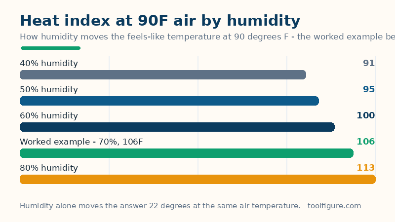
Step 3 applies two corrections at the humidity extremes. If RH is below 13% and T is between 80°F and 112°F, subtract [(13 − RH) ÷ 4] × √([17 − |T − 95|] ÷ 17). If RH is above 85% and T is between 80°F and 87°F, add [(RH − 85) ÷ 10] × [(87 − T) ÷ 5]. This page runs all three steps in order, converts Celsius inputs to Fahrenheit first — the formulas are defined in Fahrenheit — and converts the answer back.
Worked example: 90°F at 70% humidity
Start with the simple estimate: 0.5 × [90 + 61.0 + (90 − 68) × 1.2 + 70 × 0.094] = 0.5 × [90 + 61.0 + 26.4 + 6.58] = 0.5 × 183.98 = 91.99°F. Averaged with the air temperature, (91.99 + 90) ÷ 2 = 91.0°F, which is at or above 80°F, so the Rothfusz regression applies. Substituting T = 90 and RH = 70 into the nine terms gives −42.38 + 184.41 + 710.03 − 1,415.96 − 55.39 − 268.60 + 696.70 + 376.09 − 78.98 = 105.92°F, shown as 106°F (41.1°C) — 15.9°F above the air temperature, in the NWS Danger band (104–125°F). Neither humidity correction applies here, since 70% sits between 13% and 85%. Two published cross-checks confirm the implementation: 96°F at 65% humidity returns 121.0°F and 100°F at 15% humidity returns 95.8°F, both matching the values the NWS quotes. The second one surprises people — the index reads below the air temperature in very dry air — but that is the procedure's own answer, not an error: dry air lets sweat evaporate freely, and the regression reflects it. At the same 90°F, the table on the calculator shows how fast humidity moves the answer: 40% gives 91°F, 50% gives 95°F, 60% gives 100°F, the worked 70% gives 106°F and 80% gives 113°F — a 22-degree spread from humidity alone, with no change in the thermometer.
How to read your result, and its limits
Four limits decide what the number can and cannot tell you. First, it assumes shade and a light wind: the NWS notes that full sunshine can add up to about 15°F to how hot it feels, so a 106°F index in direct sun behaves more like 121°F on your skin — plan shade and water for the sunny figure, not the shaded one. Second, the bands are population guidance, not personal risk: Caution runs 80–90°F, Extreme Caution 91–103°F, Danger 104–125°F and Extreme Danger 126°F and above, but age, illness, medication, clothing and acclimatization move individual risk a long way inside any band. Third, the regression carries roughly ±1.3°F of fit error against Steadman's original table, so a 106°F result means the low-hundreds, not precisely 106 — and near a band boundary, the neighbouring band's precautions are the prudent ones. Fourth, the fitted range ends: the regression was fitted for temperatures up to about 112°F and humidity up to about 85%, and beyond it the terms climb faster than the body does — combinations that compute above 140°F are reported here as beyond the published chart rather than as a precise reading, because no honest number exists there.
Common mistakes
- Running the regression on its own in mild weather. Below about 80°F the regression drifts and can even rise as the air cools — that is exactly why the NWS procedure starts with the simple estimate and only uses the regression when the average reaches 80°F. A calculator that skips step 1 will flatter mild, humid days into false warnings.
- Reading the index as a body temperature. The heat index is an apparent temperature — how hot the air feels to a typical person in shade — not a prediction of anyone's core temperature, which depends on exertion, clothing, hydration and health.
- Forgetting the sun. The index assumes shade. Working or exercising in full sun on a 106°F-index day means planning for something closer to 121°F, and the shade figure alone will under-protect you.
- Treating a band edge as a cliff. 103°F and 104°F sit either side of the Extreme Caution–Danger line, but the body does not notice the boundary: near an edge, take the higher band's precautions.
Related tools: Wind Chill Calculator — How cold it really feels — the official wind chill from temperature and wind speed, with the frostbite-risk band; Temperature Converter — Convert °C, °F, K, °R and °Ré — every answer in all five scales, formulas shown; Camping Water Purification Calculator — The iodine dose for your camp water — drops or tablets per litre, and the wait before drinking, doubled for cloudy or cold water.
Frequently asked questions
What is the heat index, exactly?
The heat index is the apparent temperature — how hot the air feels to a typical person — combining air temperature and relative humidity. It was developed from R. G. Steadman's physiological model and is the feels-like temperature the US National Weather Service uses in summer heat forecasts.
Why does the calculator sometimes use a simple formula instead of the main one?
Because the main Rothfusz regression was fitted to hot conditions and drifts badly below about 80°F. The NWS procedure therefore computes a simple estimate first and only uses the regression when that estimate, averaged with the air temperature, reaches 80°F. Mild days get the simple estimate, which is the honest answer there.
Why can the heat index read below the air temperature in dry air?
Because dry air lets sweat evaporate freely, which cools the skin below the thermometer reading. At 100°F and 15% humidity the NWS procedure returns 95.8°F — below the air temperature — and that is the correct result, not a bug.
Does the heat index account for sunshine or wind?
No: it assumes shade and a light wind. Full sunshine can add up to about 15°F to how hot it feels, and a strong wind changes comfort in ways the index does not model. Treat the index as the shaded figure and add the sun's contribution yourself.