The Bureau of Meteorology formula
The apparent temperature is the Australian Bureau of Meteorology's feels-like temperature, and its virtue is that it takes all three readings that decide comfort — air temperature, humidity and wind — where the heat index takes two and the wind chill takes two different ones. The standard form used here, without a solar-radiation term, is:
AT = Ta + 0.33 × e − 0.70 × ws − 4.0 — where e = (RH ÷ 100) × 6.105 × exp(17.27 × Ta ÷ (237.7 + Ta))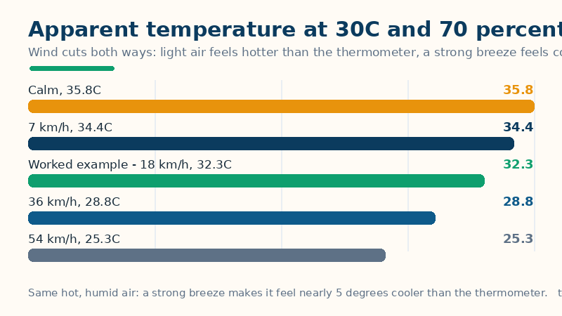
Here Ta is the air temperature in degrees Celsius, RH is the relative humidity as a percentage, e is the vapour pressure of the air in hectopascals, and ws is the wind speed in metres per second. The three terms pull in different directions, and that is the whole point: the humidity term (+0.33 × e) warms the answer, because moist air slows sweat evaporation; the wind term (−0.70 × ws) cools it, because moving air strips heat from the skin; and the constant −4.0 centres the scale so the result reads as a temperature. The fuller Bureau version adds a solar term, +0.70 × Q ÷ (ws + 10), where Q is the solar radiation in watts per square metre — but forecasts rarely publish Q, so this page uses the no-radiation form and states the omission, rather than inventing a sun figure. Fahrenheit temperatures are converted to Celsius before the formula runs, and wind speeds in km/h or mph are converted to metres per second.
Worked example: 30°C, 70% humidity, 18 km/h wind
First convert the wind: 18 km/h ÷ 3.6 = 5.00 m/s. Then the vapour pressure: e = 0.70 × 6.105 × exp(17.27 × 30 ÷ (237.7 + 30)) = 0.70 × 6.105 × exp(518.1 ÷ 267.7) = 0.70 × 6.105 × exp(1.9355) = 0.70 × 6.105 × 6.926 = 29.60 hPa. Then the apparent temperature: AT = 30 + 0.33 × 29.60 − 0.70 × 5.00 − 4.0 = 30 + 9.77 − 3.50 − 4.0 = 32.27°C, shown as 32.3°C — 2.3°C warmer than the air. The wind table on the calculator shows the same afternoon at other wind speeds: calm air gives 35.8°C, a light 7 km/h breeze gives 34.4°C, the worked 18 km/h gives 32.3°C, a fresh 36 km/h breeze gives 28.8°C — already cooler than the thermometer — and a strong 54 km/h breeze gives 25.3°C, nearly 5 degrees cooler than the air it started from. Three cross-checks confirm the implementation: 25°C at 60% humidity with a 3 m/s wind returns 25.2°C, 35°C at 50% with 2 m/s returns 38.8°C, and 20°C at 80% with an 8 m/s wind returns 16.6°C. The imperial restatement of the worked example — 86°F, 70% humidity, 11 mph — returns about 90.2°F, as it must, since it is the same air converted twice.
How to read your result, and its limits
Three readings come out of one number. First, the crossover wind speed is the story: for any hot, humid afternoon there is a wind speed at which the cooling term exactly cancels the humidity term, and above it the air feels cooler than the thermometer says — that is why a sea breeze rescues a humid day while still air makes it oppressive. Second, this is a comfort model, not a safety model: it has no danger bands of its own, because the Bureau publishes it as a temperature, and in genuinely dangerous heat the heat index bands or the humidex bands are the safety guide, not this figure. Third, the sun is missing by design: the no-radiation form describes shaded conditions, and full sun adds warmth the formula cannot see — treat a sunny apparent temperature as an underestimate. In cold weather the formula's logic inverts badly: it was built for warm-weather comfort, and frostbite risk belongs to the wind chill calculator, whose formula and bands are fitted to cold skin, not to this equation.
Common mistakes
- Feeding it a gust instead of a steady wind. The formula is defined for a steady wind speed. A gust of 40 km/h inside a 15 km/h breeze will drag the answer down by several degrees for a condition that lasts seconds — use the sustained wind, or the average over a few minutes.
- Expecting wind to always cool. At low wind speeds the humidity term dominates, so a light breeze on a humid day still leaves the air feeling hotter than the thermometer. Wind only starts winning once the −0.70 × ws term outruns +0.33 × e, and the table shows exactly where that happens.
- Using it for frostbite risk. A cold, windy result from this formula is not a wind chill: the wind chill equation is fitted to heat loss from exposed skin in the cold, with its own frostbite timers. Use the right index for the season.
- Forgetting the missing sun term. The fuller Bureau formula adds solar radiation; this page's form does not, because forecasts rarely publish it. A sunny apparent temperature therefore reads low — add your own allowance for direct sun, as you would for the heat index.
Related tools: Wind Chill Calculator — How cold it really feels — the official wind chill from temperature and wind speed, with the frostbite-risk band; Heat Index Calculator — How hot it really feels — the official NWS heat index from temperature and humidity, with the danger band; Humidex Calculator — How hot humid air feels in Canada — the official humidex from temperature and humidity, with its discomfort band.
Frequently asked questions
What is apparent temperature, exactly?
The apparent temperature is the Australian Bureau of Meteorology's feels-like temperature: the temperature the air seems to be once humidity and wind are taken into account. It combines air temperature, relative humidity and wind speed into a single figure on the Celsius scale.
How is it different from the heat index or wind chill?
The heat index combines temperature and humidity but ignores wind; wind chill combines temperature and wind but ignores humidity. Apparent temperature is the only one of the three that takes all three readings at once — which is why it can show a hot, humid afternoon feeling cooler than the thermometer once the wind picks up.
Why can the apparent temperature be lower than the air temperature on a hot day?
Because the wind term (−0.70 × wind speed) grows with the wind while the humidity term stays fixed: at a strong breeze the cooling from moving air outweighs the warming from humidity, and the same 30°C, 70% afternoon drops from 35.8°C in calm air to 25.3°C at 54 km/h.
Does it account for sunshine?
Not in this form. The fuller Bureau formula adds a solar-radiation term, but forecasts rarely publish solar radiation, so this page uses the standard no-radiation form — effectively a shaded figure — and a sunny day will feel warmer than the number shown.